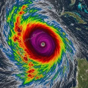
Potential Tropical Cyclone Nine is rapidly organizing over the northwestern Caribbean and is expected to strengthen into Tropical Storm Helene, with conditions favorable for further intensification. Warm ocean waters and a supportive atmosphere could allow the system to become a hurricane as it moves northward through the Yucatán Channel and into the Gulf of Mexico. Forecasters are closely monitoring the development of a more defined circulation center, which could signal faster strengthening.
Current projections show the system moving toward Florida, with the Florida Panhandle and West Central Florida among the areas potentially at risk. Forecast models indicate that Helene could reach hurricane strength before landfall, with some scenarios suggesting the possibility of becoming a major hurricane. However, even relatively small changes in the storm’s track could shift where the strongest impacts occur, so residents throughout Florida and nearby states should continue monitoring official forecasts.
The storm could bring several dangerous hazards beyond strong winds. Heavy rainfall may cause flash flooding, while coastal communities could face a significant storm surge. Outer rain bands may also produce hazardous conditions well away from the storm’s center, meaning areas across Florida, Georgia, South Carolina, and other parts of the Southeast could experience impacts even if the hurricane’s eye does not pass directly overhead.
Residents in areas that may be affected are encouraged to review hurricane plans, know evacuation routes, and prepare essential supplies such as water, non-perishable food, medications, flashlights, batteries, and backup power sources. Because tropical systems can change in strength and direction quickly, people should follow updates from the National Hurricane Center and local emergency officials and obey any evacuation or safety instructions that are issued.